The Wilderness Committee has created a series of maps to track the route of the proposed – and existing – Trans Mountain pipeline (formerly Kinder Morgan) and associated oil tanker route. Check out the maps below for detailed views of the pipeline route as it crosses BC, through critical salmon-bearing watersheds, the Fraser Valley and Lower Mainland, as well as the tanker route passing through the delicate ecosystem of the Salish Sea.
To view the interactive map that allows you to zoom in on satellite images, click here.
To view a map showing other proposed oil and gas pipelines (and affected parks) in northern BC, click here.
---------------------
New Updated Maps from February 2021:
Proposed Trans Mountain Tar Sands Pipeline Route in Fraser Valley - From Abbotsford to Hope (updated Feb 2021)
Detailed community-level map showing the permitted New Pipeline Right-of-Way, existing pipeline, and proximity to schools, waterways and endangered wildlife habitat.
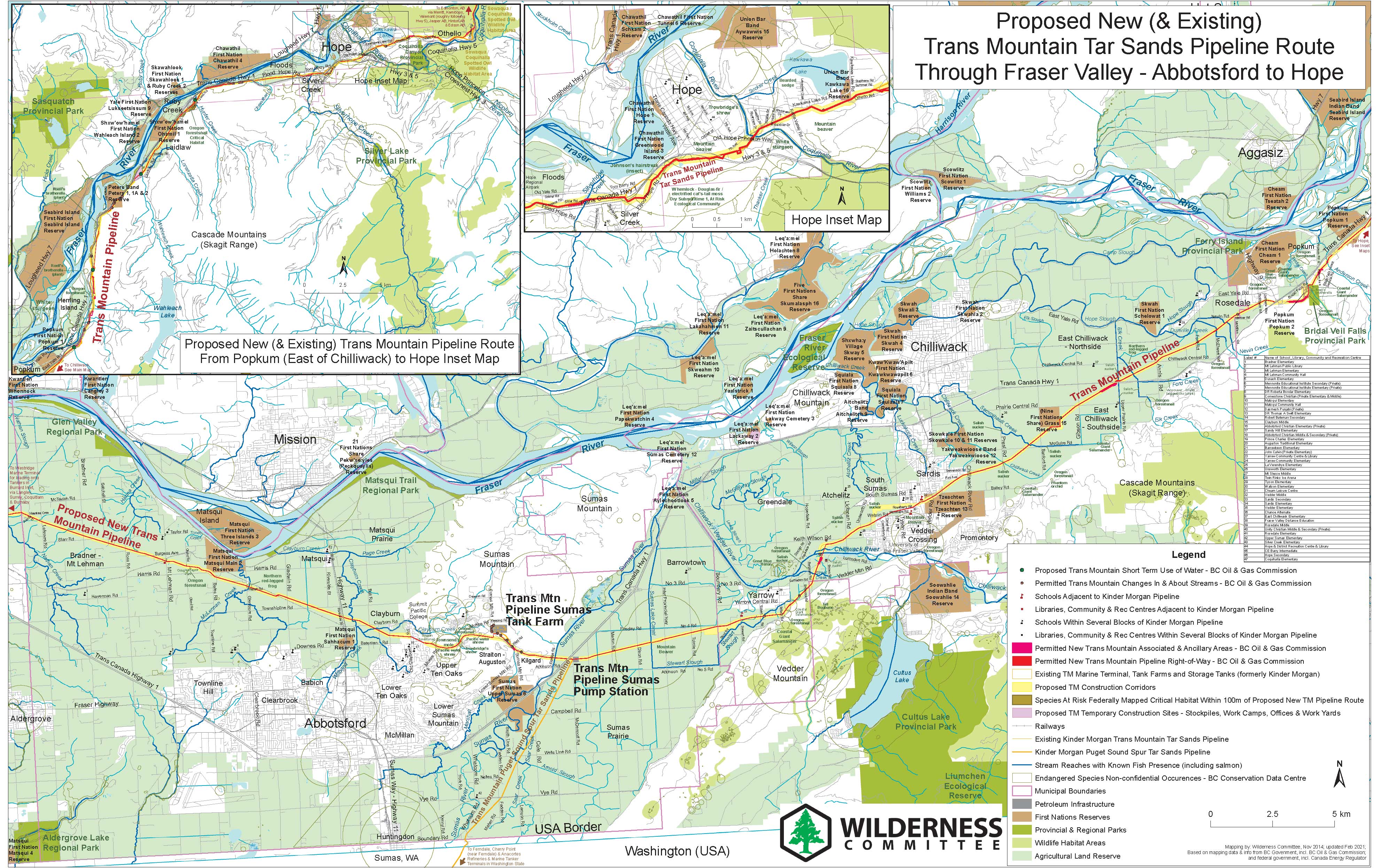
Download this map in .PDF format
Map of Trans Mountain Pipeline Right-of-Way in and around Brunette River Conservation Area in Burnaby (Updated Feb 2021)
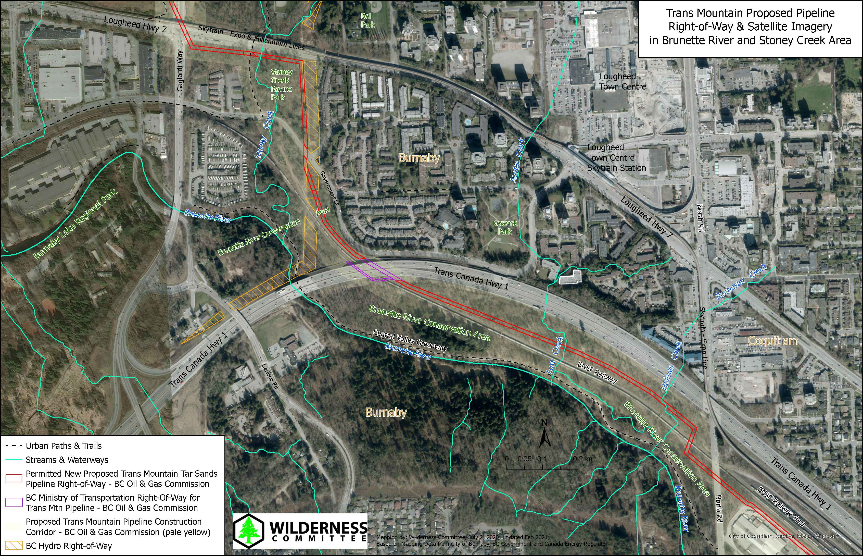
Download this map in .PDF format
---------------------
Updated Maps from June 2020:
Map of Trans Mountain Pipeline Priority Construction Areas for Summer Fall 2020 and Detailed Route in Burnaby, Coquitlam and Surrey (Updated June 2020)
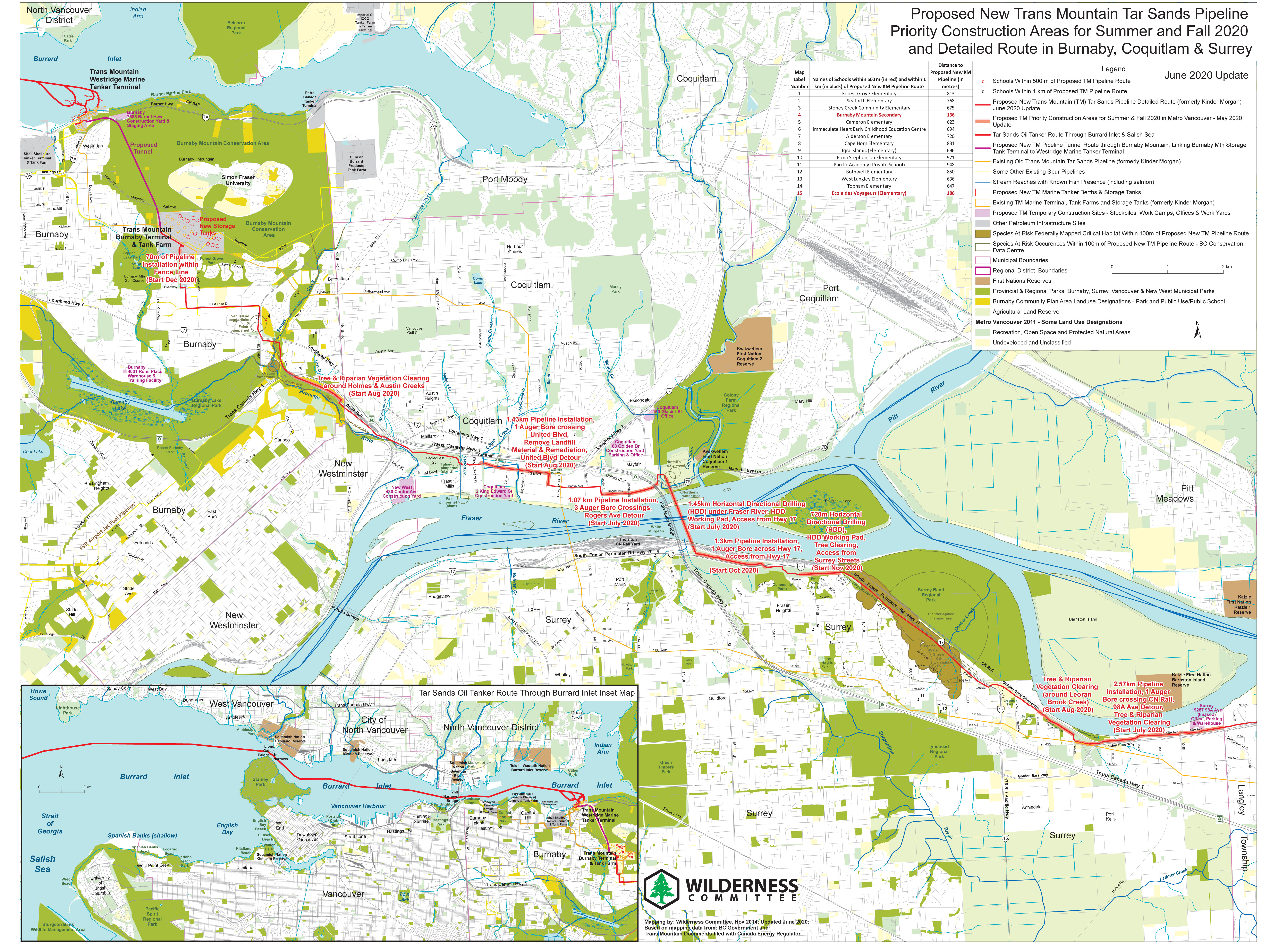
Download this map in .PDF format
Maps from March 2018:
Kinder Morgan Burnaby Mountain Storage Tank Terminal Injunction Site with 5 m Buffer (updated Mar. 2018)
Also shows Active Logging Areas, Protest Camps, Proposed New Storage Tanks and Proposed New Tar Sands Pipeline Route in the area.
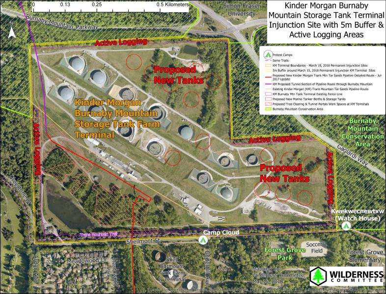
Download this map in .pdf format
Kinder Morgan Westridge Tanker Terminal Injunction Site with 5 m Buffer (updated Mar. 2018)
Also shows Active Construction & Logging Areas, and Proposed New Tanker Berths and Proposed New Tar Sands Pipeline Route in the area.
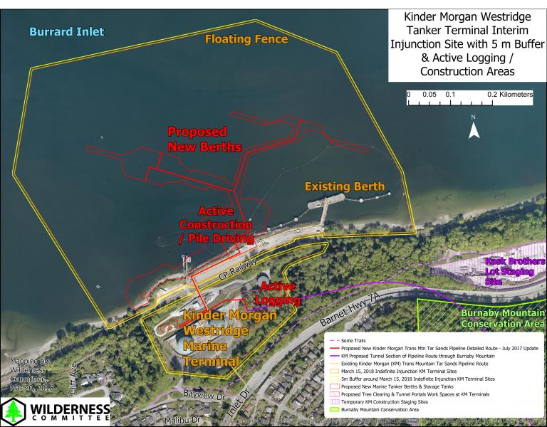
Download this map in .pdf format
Proposed Kinder Morgan Trans Mountain Tar Sands Pipeline & Terminals in Burnaby (updated Mar. 2018)
Detailed community-level map showing the proposed New Kinder Morgan Pipeline Detailed Route, existing pipeline, Westridge Tanker and Burnaby Storage Tank Terminals, satellite imagery and Construction Plans.

Download this map as larger .JPG image format
Proposed Kinder Morgan Trans Mountain Tar Sands Pipeline & Terminals in Burnaby (updated Mar. 2018)
Detailed community-level map showing the proposed New Kinder Morgan Pipeline Detailed Route, existing pipeline, Westridge Tanker and Burnaby Storage Tank Terminals, and Construction Plans.
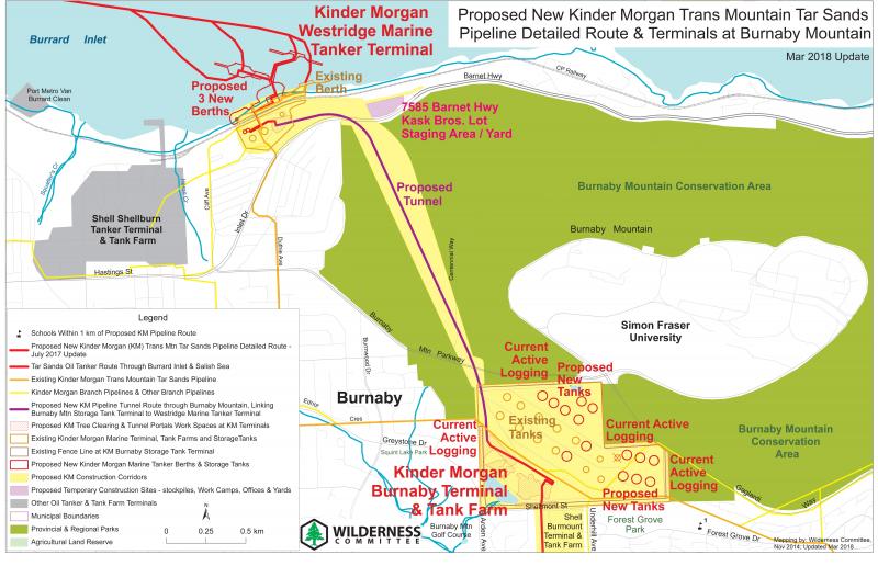
Download this map in .pdf format
Proposed Kinder Morgan Trans Mountain Tar Sands Pipeline in Burnaby & Coquitlam (updated Mar. 2018)
Detailed community-level map showing the proposed New Kinder Morgan Pipeline Detailed Route, existing pipeline, and proximity to schools, waterways and endangered wildlife habitat.
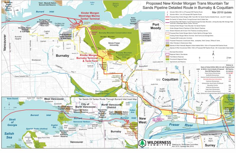
Download this map in .pdf format
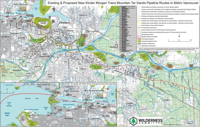
Proposed Kinder Morgan Trans Mountain Tar Sands Pipeline in Metro Vancouver (updated Mar. 2018)
Detailed community-level map showing the proposed New Kinder Morgan Pipeline Detailed Route, existing pipeline, and proximity to schools, waterways and endangered wildlife habitat.
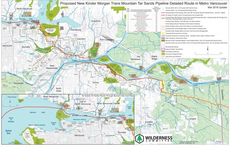
Download this map in .pdf format
Proposed Kinder Morgan pipeline route impacting Burnaby Mountain Conservation Area (updated Nov. 2014)
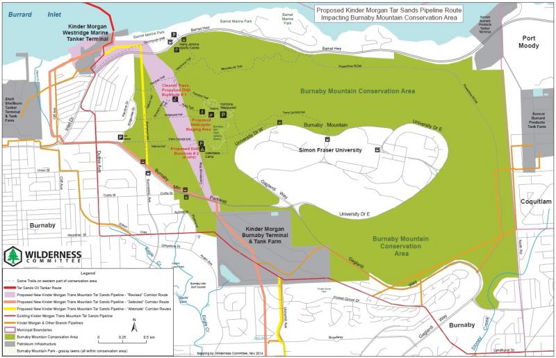
Download this map in .pdf format
Interactive Map: Kinder Morgan Trans Mountain Pipeline Project
(Focused on Burnaby Mountain, Burnaby and Coquitlam) - updated Nov 2014
The existing pipeline is shown in yellow, the proposed preferred new pipeline corridor route is shown in red and alternate routes being considered are in light purple. The exact final route has not been completely decided, but the routes depicted are based on maps submitted in Kinder Morgan's application to the National Energy Board in December 2013. This map was updated in August 2014 with "revised" corridor route sections shown in orange through Burnaby (including Burnaby Mountain) and Coquitlam. Also shown in dark green are BC parks that will be potentially impacted by the new Kinder Morgan pipeline (according to BC government documents), and in light green other parks that may be potentially impacted by the pipeline. Additional icons depict some sites visited recently by the Wilderness Committee on Burnaby Mountain, including the concerned citizens/defenders camp (on site of proposed test borehole #2) and a site cleared of trees by Kinder Morgan contractors (proposed test drill borehole site #1) and a helicopter staging area. Also shown are Kinder Morgan's Burnaby tank farm and Westridge Marine terminals, and the boundary of Burnaby Mountain Conservation Area. Click on icons and terminals for more info.
You can toggle the legend, zoom in or change the basemap imagery with the buttons across the top. You can pan around map by clicking on map and dragging with your mouse. Click 'View Larger Map' below map to open the map in ArcGIS Online map viewer.
Trans Mountain Pipeline in Metro Vancouver (updated Nov. 2014)
Detailed community-level map showing both "alternative" routes, including schools, waterways and endangered wildlife habitat
Download this map in .pdf format
Trans Mountain Pipeline in the Fraser Valley (updated Nov. 2014)
Detailed community-level map including schools, waterways and endangered wildlife habitat along route
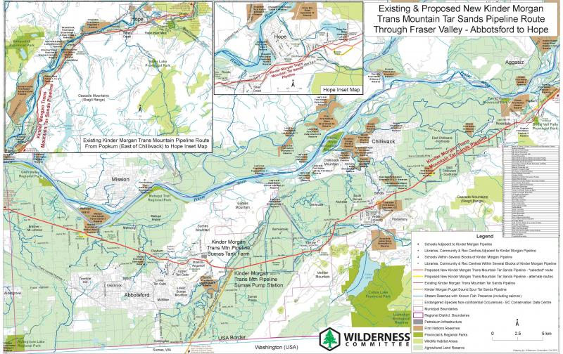
Download this map in .pdf format
Trans Mountain Pipeline from Hope to Merritt, BC (updated Jan. 2014)
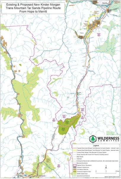
Download this map in .pdf format
Trans Mountain Pipeline from Merritt to Kamloops, BC (updated Jan. 2014)
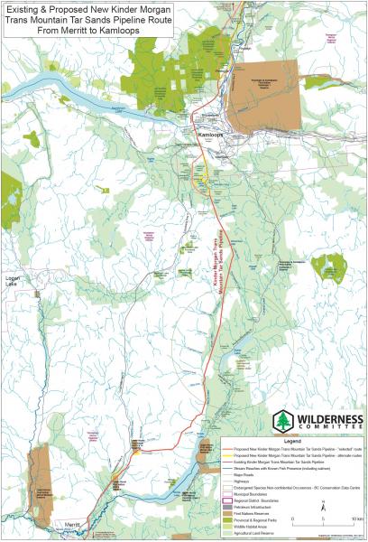
Download this map in .pdf format
BC Parks and Protected Areas Potentially Affected by the proposed Kinder Morgan pipeline
Note: these parks will have (or already have some new pipe, such as Jasper and Mt Robson) within them or adjacent or very close, such that they may be "potentially" impacted by Kinder Morgan new pipeline, including: by a bitumen spill/pipe rupture and/or being traversed by new pipe.
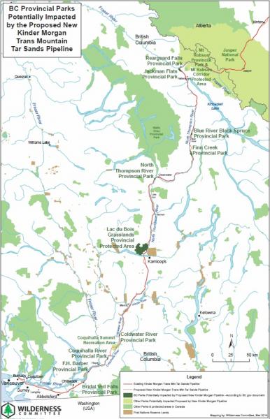
Download this map in .pdf format
Salish Sea Carbon Corridor (Kinder Morgan pipeline/tanker route and coal shipping routes)
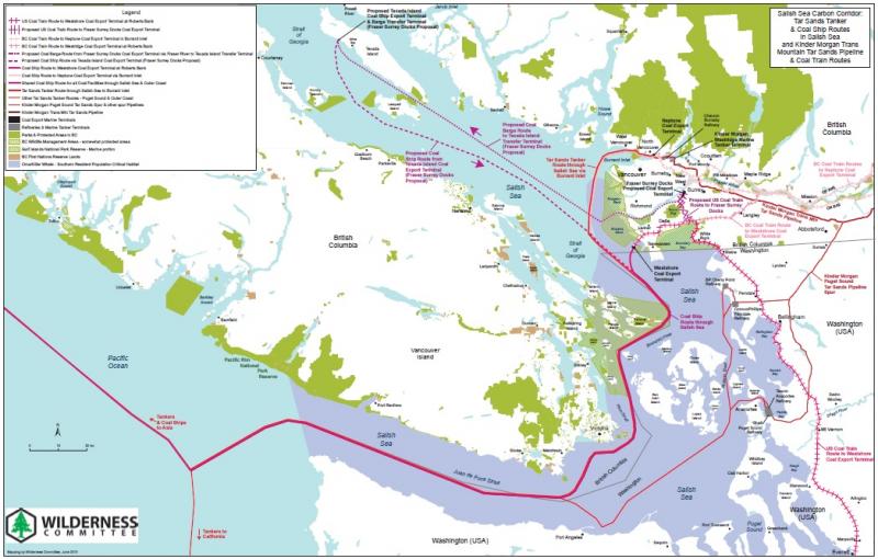
Download this map in .pdf format
Trans Mountain Pipeline associated tanker route through the Salish Sea
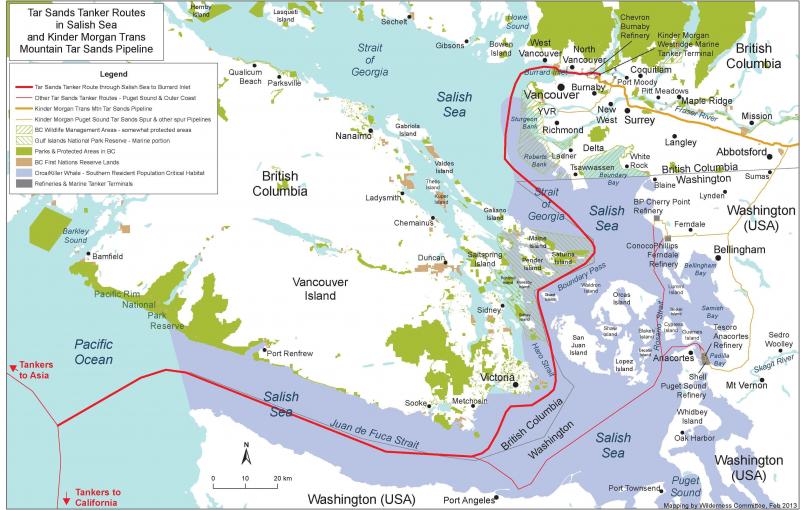
Download this map in .pdf format
Trans Mountain Pipeline through the Fraser River Watershed
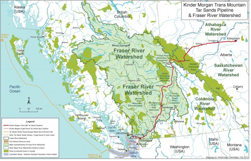
Download this map in .pdf format
Trans Mountain Pipeline Vancouver Harbour/Burrard Inlet Map
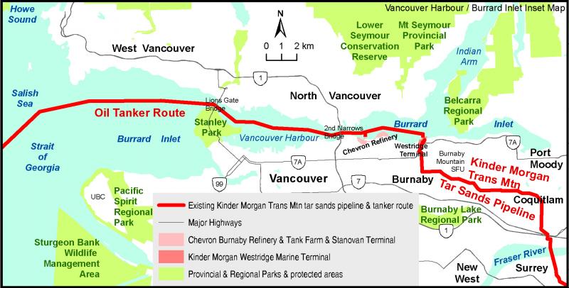
Download this map in .pdf format
Trans Mountain Pipeline Full Route Map

Download this map in .pdf format
For additional maps and detailed route information around the Fraser Valley, visit our allies at the PIPE UP Network.